 |
| click for larger |
Ley lines are alleged alignments of a number of places of geographical interest, such as ancient monuments and megaliths, natural ridge-tops and water-fords. Their existence was suggested in 1921 by the amateur archaeologist Alfred Watkins, in his books Early British Trackways and The Old Straight Track. Watkins theorized that these alignments were created for ease of overland trekking by line of sight navigation during neolithic times and had persisted in the landscape over millennia. In more recent times, the term ley lines has come to be associated with spiritual and mystical theories about land forms, including Chinese feng shui.
(definition taken from www.en.wikipedia.org/wiki/Ley_line )The existence of these apparently remarkable alignments between sites is easily demonstrated. However, the causes of these alignments are disputed. There are three major schools of thought:
- Anthropological: According to proponents of some ley line theories, the early inhabitants of Great Britain determined the placement of Stonehenge and various other megalith structures, buildings, monuments, or mounds according to a system of these lines, which often pass through, or near, several such structures. Some of these theories believe leys to have had some astronomical significance, or to relate to traditional religious beliefs associated with these sites. Others simply see leys as marking trade routes.
- New Age: Some have claimed that these points resonate a special psychic energy. These theories often include elements such as geomancy, dowsing or UFOs.
- Skeptical: Skeptics of these ley line theories believe that they belong in the realms of pseudoscience or magic. Most skeptics believe that ley lines can be explained completely by chance alignments that appear intuitively unlikely, but can be demonstrated to be unsurprising coincidences. Some skeptics are investigating if these points have electrical or magnetic forces associated with them.

In 1921, when he realized the existence of ancient alignments, Alfred Watkins was sixty-six years old. The complex rhythm of the twentieth century had barely begun, particularly in the rural county of Herefordshire. As a partner in a firm of flour millers, Watkins needed to make frequent tours of the local countryside, and there is no doubt that he was a man with his native landscape 'in his blood'. He was a respected local figure and highly regarded at a national level for his work in photography. A man of broad interests, independent thought and varied talents, his mind was open, exploratory and not restricted within the con fines of a single discipline. In addition, he had spent a great part of his life getting to know, at a direct and intimate level, his local countryside and its inhabitants. He knew its lore, its ancient sites and its little-known places. The appropriate mind and physical circumstances were set up for the flash of insight that came on a summer's day in 1921. It was like experiencing 'a flood of ancestral memory', Watkins was to tell his son, the late Allen Watkins. In his own words, Watkins describes his insight in his book Early British Trackways:
I had no theory when, out of what appeared to be a tangle, I got hold of the one right end of this string of facts, and found to my amazement that it unwound in an orderly fashion and complete logical sequence...
A visit to Backwardine led me to note on the map a straight line starting from Croft Ambury, lying on parts of Croft Lane past the Broad, over hill points, through Backwardine, over Risbury Camp, and through the high ground at Stretton Grandison, where I surmised a Roman station. I followed up the clue of sighting from the hilltop, unhampered by other theories, found it yielding astounding results in all districts, the straight lines to my amazement passing over and over again through the same class of objects...
After his realization that alignments of ancient sites existed, Alfred Watkins committed himself to detailed fieldwork investigation, frequently taking photographs of sites, alignments and other features he came across in this work. His first, short, book on his discovery, Early British Trackways, came out in 1922 and was the development of a lecture he had delivered a year previously. He continued his study of the alignments, and his main book on the subject, The Old Straight Track, was published in 1925. Later books were The Ley Hunter's Manual (1927) and Archaic Tracks Around Cambridge (1932). A little after the publication of The Old Straight Track the Straight Track Postal Portfolio Club was formed, in which ley hunters circulated postal notes, viewpoints, research and photographs amongst themselves. Major F. C. Tyler was secretary of the club, which, in the Thirties, organized field trips for its members. These took the form of special tours around chosen areas, often in fleets of cars.
But the deaths of Watkins and Tyler in the Thirties, and the coming of the Second World War, took the impetus out of the club, and it was closed in 1948. A handful of individuals and fringe groups kept a caretaker's interest, as it turned out, in Watkins's work up until the Sixties when a whole new cycle of interest in leys began to form.
Alfred Watkins felt he had caught a glimpse beyond the modern face of the landscape and was tracing the remnants of a system of straight trackways belonging to remote antiquity. He postulated that these tracks were laid out with certain types of markers, some of which may have developed into sacred or important sites in both pagan and Christian times. Some ley markers were therefore original while many others were evolved features, such as ancient churches and castles, standing on sites of former significance. Odd sections of the old straight tracks were still visible, Watkins thought, in some lengths of roadway and old paths aligning on ancient sites. He considered that some of his alignments had astrological significance.
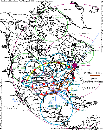
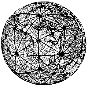
Alignments and patterns of powerful, invisible earth energy said to connect various sacred sites, such as churches, temples, stone circles, megaliths, holy wells, burial sites, and other locations of spiritual or magical importance. The existence of leys is controversial. If they do exist, their true age and purpose remain a mystery. Watkins suggested that all holy sites and places of antiquity were connected by a pattern of lines he called 'leys'. Mounds, barrows, tumuli, stones, stone circles, crosses, churches built on pagan sites, legendary trees, castles, mottes and baileys, moats, hillforts, earthworks and holy wells were all thought to stand in alignment. Using the Ordnance Survey, Watkins claimed that the leys were the 'old straight tracks', which crossed the landscape of prehistoric Britain and represented all types of early human activities. Points where the ley energy paths intersect are said to be prone to anomalies such as earth lights and poltergeist phenomena and reported sightings of UFOs (one theory suggests that the paths are navigational aids to extraterrestrial spacecraft). These energy leys, however, do not necessarily coincide with physical alignments of sites. Despite the controversy ley researchers hope at least to come to a better understanding of ancient sacred sites, and of the people who built them.
Parapsychologists have found that many of the most famous poltergeist cases have happened at the intersection of two ley lines. These are said to be a network of earth energy lines that criss-cross the country. The prehistoric inhabitants of ancient Britain were supposedly aware of these lines of force and built their monuments on the most important concentrations of these fields. Stonehenge is a prime example.
The forces that use the ley lines are natural and supernatural. Some of the strange and supernatural events and forces associated with ley lines are The Wild Hunt, phantom animals (Black Dog), moving lights, ghosts, fairy processions, and as a flight path for witches. It is thought that the creators of the ley lines in each area may have used the ley lines in connection with astronomy, rituals, or calendars.
In some cultures the ley lines were to be used specifically for the dead to help them make their journey into the next life. In ancient times, people believed in the survival of the human spirit and it is believed that the ley system proves it. In Honaluba a small girl found herself alone on a known spirit path. She heard marching footsteps but when she turned, no one was there! Suddenly, she felt a hand push her from the path. Her parents explained to her that the path was for wondering souls and if she had remained in the path she would have died.
Ancient burial grounds were placed on ley lines. In Germany these are called Geisterwege (spirit ways); in Holland they are called Doodwegen (roads of the dead); and in England they are Dod or Dodman (dead man). One ley network involves the Foulford Inn Stone which is encircled by burial grounds connecting two cup-marked leys with a straight line through a man made cave and over a body of water. The Stone was placed above a major fault on the highland fault, north of Scotland. This is where Scotland pushes against the rest of the United Kingdom. This fault supplies the cup marked stone with its energies.
Another system involves a standing stone called the Phadruig (Patrick) near Balquhidder Church and is known as a very powerful cup marked ley. Tradition dictates that whenever someone dies, the mourners would have to carry the dead across the land to the stone where the coffin would be laid upon it so everyone could rest. In addition to this tradition, coffins were frequently carried along ley lines with hopes that the dead would find their way down the path.
For years, many have tried to solve the ley system to discover its purpose, why it exists, and who created it. This is difficult to discern as there is very little recorded about the ley system and few people seem interested in researching it scientifically. In the 1960's for example, the ley system became associated with UFO's. Even with the amazing discovery of the Nazca leys, very little has been done.
Spectral paths between cemeteries in Germany, for example, are known as
geister wegen. Cursuses, found between megalithic sites in Great Britain, were possibly
ancient, processional routes between places of burial. Of course, these pathways are
believed to be haunted.
“Corpse roads” were direct paths that the bodies of the deceased would be hauled down as
they were taken to the graveyard. They have also been called church ways, burial roads, and
coffin lines, spawning quite a bit of folklore about ghosts and spirits haunting these old
pathways.
In separate cases of haunting, it is well known that multiple witnesses occasionally report
seeing the same ghosts repeatedly walking the same paths over and over again. This leads
us to wonder if earthbound spirits also roam the routes between burial places? We would
have to assume it is possible. If ghosts from the past, who possibly haunt these trails, are
disrupted by people, buildings, etc, will they make their displeasure known? In other words, if
someone unknowingly builds a structure on one of these ancient paths, could they be
haunted by an angry ghost? It is possible. Could this explain why some ghosts, who might
believe they are still walking an old road, manifest through walls and other solid objects?
http://www.gothicimage.co.uk/books/leyhunter1.html
http://www.occultopedia.com/l/ley_lines.htm
http://www.psychics.co.uk/ghosts/leylines.html
http://www.spiritsociety.org/ghost.php?page=articles&article=leylines1.html http://www.angelsghosts.com/ghosts_ley_lines
No comments:
Post a Comment